INDIANAPOLIS – The National Weather Service (NWS) in Indianapolis is monitoring a winter weather system that could move into the state later this week. Snow, sleet, and freezing rain are likely Tuesday night through Thursday.
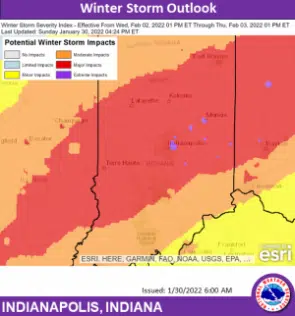
The latest information is showing a potential for a significant impact on the south-central Indiana area. Forecast uncertainty on specifics remains high. NWS will continue to update Hoosiers during the next few days.
At this point, Columbus seems to be on the edge of the moderate/major impact zone, while Franklin is in the major impact zone. Seymour and North Vernon are in the moderate zone. It is too early for a definitive forecast.
NWS says now is the time to prepare. Ensure that you have a full tank of gas in your vehicles and emergency kits are stocked and ready to go. You are advised to also check the batteries in your portable radio and flashlights.